ΑΓΓΕΛΙΑ
ΕΝΟΙΚΙΑΖΕΤΑΙ ΟΙΚΟΠΕΔΟ 1760 Μ2- ΛΑΘΕΑ Α’ ΑΧΑΡΝΕΣ,πλησίον supermarket “ΣΚΛΑΒΕΝΙΤΗ» Λεωφόρου Πάρνηθος
ΕΠΙΚΟΙΝΩΝΙΑ:polisisnet@gmail.com, 210-2449325
ENHMEΡΩΣΗ ΑΝΑΓΝΩΣΤΩΝ/INFORMATION BULLETIN
AΠΟ ΤΟ ΤΕΛΟΣ ΠΡΟΣΕΧΟΥΣ ΔΕΚΕΜΒΡΙΟΥ 2026 Η ΝΕΑ ΙΣΤΟΣΕΛΙΔΑ ΤΗΣ ΕΦΗΜΕΡΙΔΑΣ, ΘΑ ΕΧΕΙ ΝΕΑ ΗΛΕΚΤΡΟΝΙΚΗ «ΔΙΕΥΘΥΝΣΗ» Η ΟΠΟΙΑ ΘΑ ΣΑΣ ΑΝΑΚΟΙΝΩΘΕΙ ΕΓΚΑΙΡΩΣ.ΤΑ ΕΝΗΜΕΡΩΤΙΚΑ ΔΕΛΤΙΑ ΣΑΣ..παρακαλούμε να αποστέλλονται πλέον στην νέα ανακοινωθείσα διεύθυνση.
Αναμείνατε νεώτερη ανακοίνωσή μας.
STARTING NEXT DECEMBER 2026 END, THE NEWSPAPER'S NEW WEBSITE WILL HAVE A NEW EMAIL "ADDRESS" WHICH WILL BE ANNOUNCED TO YOU IN DUE COURSE. Please ensure that your after December press releases are sent to the newly announced address from that point onward.
Please await our further announcement...
EARTHDATA DISCOVERY,update
| | | | | | | |  | | | | OPEN ACCESS FOR OPEN SCIENCE | FEBRUARY 2024 |
| | | | | | | |
|
| | | | | | 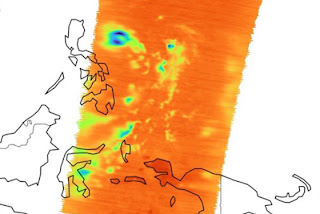 | | | | | | | | | | | | | | | | Getting tropical storm data rapidly helps manage these destructive events. Provisional data are now available from the Time-Resolved Observations of Precipitation structure and storm Intensity with a Constellation of SmallSats (TROPICS) mission. | | | | | |
| | | | | | | Near-hourly observations of temperature, humidity, cloud ice and precipitation horizontal structure data from TROPICS are available through Earthdata Search. | Explore TROPICS Data | | | | | | |
| | | | |  | | Articles | | | | | |
|
| | | | | |  | | Supporting the Best SWOT Science
Careful calibration and validation ensure that the Ka-band Radar Interferometer (KaRIn) instrument aboard the Surface Water and Ocean Topography (SWOT) satellite collects the best science-quality data possible. | | | | | | | | 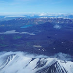 | | Keeping a Close Eye on Distant Volcanoes
A NASA-funded online archive is making synthetic aperture radar (SAR) data easier to work with. Researchers used imagery from this archive in first-of-its-kind research measuring volcanic deformation in the remote Aleutian Islands. | | | | | | | |  | | New Standard for Using GeoTIFF
NASA’s Earth Science Data Systems (ESDS) Program is adopting a new Open Geospatial Consortium (OGC) data standard for using Geographic Tagged Image File Format (GeoTIFF) imagery files in cloud environments. | | | | | | | |  | | NASA Takes Pollution Monitoring to New Heights
NASA’s Tropospheric Emissions: Monitoring of POllution (TEMPO) is the agency’s first air quality monitoring instrument in geostationary orbit. The mission is part of an international satellite constellation to track global air pollution. | | | | | | | |  | | Canada Experiences a Warm End to 2023
The Canadian winter in December was warmer than expected. An analysis of December global surface air temperature and precipitation data shows day and night temperatures almost 12 degrees Fahrenheit warmer than average. | | | | | |
| | | | | |  | | Webinars & Events | | | | | |
|
| |  | | | | | | | | Coming Soon: Explore the Openscapes Earthdata Cloud Cookbook February 28, 2024 | | | | | | | | NASA Openscapes supports researchers in migrating workflows to the Cloud. This webinar features the Openscapes Earthdata Cloud Cookbook: a compilation of tutorials, workflows, and libraries that help users find, access, and apply Earth science data. | | | | | |
| | | | | | In Case You Missed It: Discover and Access Earth Science Data Using Earthdata Search This webinar highlights the key features of Earthdata Search and provides demonstrations on how to search for, discover, and access Earth science data.
| | 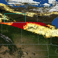 | | | | | | | | EMIT Data Tutorial Series March 14, 2024, 3 p.m. ET Learn how to use the methane data products from NASA’s Earth Surface Mineral Dust Source Investigation (EMIT) mission. The workshop features presentations by the EMIT science team and NASA’s Land Processes Distributed Active Archive Center (LP DAAC).
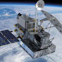
| | 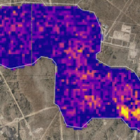 | | | | | | | | GPM 10-in-10 Webinar Series March 14, 2024, 8 p.m. ET To celebrate the 10-year anniversary of the Global Precipitation Measurement (GPM) mission’s launch, the GPM team is hosting 10 webinars in 2024 focusing on precipitation measurement from space. The second webinar is Earth's Water.
| |  | | | | | |
| | | | |  | | New Data, Tutorials, & Resources | | | | | |
| | NASA Earth Science Data Roundup Read summaries of data, products, and resources released by NASA’s Distributed Active Archive Centers (DAACs) over the past month. | | | | | | | | Data Tool in Focus: Earthdata Search Earthdata Search enables users to discover and access more than 50,000 NASA Earth science data collections as well as collections from U.S. and international agencies. | | | | | | | | earthaccess: Earth Science Data Access Simplified A new Python application programming interface (API) library called earthaccess makes it easy to access NASA Earth science data using only a few lines of Python code. | | | | | | | | Updated FIRMS User Interface NASA’s Fire information for Resource Management System (FIRMS) released an expanded User Interface (UI) for both FIRMS Global and FIRMS US/Canada. The updated UI makes it easier to filter and visualize data, among other enhancements. | | | | | | | | Updated Science Discovery Engine Interface Discovering data, documentation, and code across the five divisions comprising NASA’s Science Mission Directorate is easier and more efficient thanks to an updated user interface for the Science Discovery Engine. | | | | | |
| | | | | |  | | Open Science | | | | | |
| | | | | |  | | Open Science 101 Now Available Open Science 101 is a free public training to equip participants with the knowledge and skills to navigate the principles and practices of open science. Register today and complete the course to receive your NASA Open Science digital badge. | | | | | |
| | | | | |  | | Connect with NASA Earth Science | | | | | |
| | | | | |  | | Worldview Images of the Week | | | | | |
| | 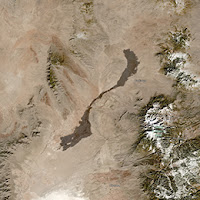 | | Prehistoric Lava Flow in New Mexico Sometime in the last 1,000 to 5,000 years, lava began flowing in what is today south-central New Mexico. The Carrizozo volcanic field comprises two flows: the Broken Back flow to the south and the Carrizozo lava flow to the north. | | | | | | | | 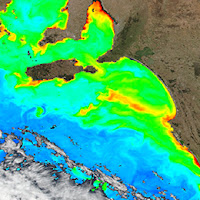 | | Colorful Blooms in Australia The colors in this image are near-surface concentrations of chlorophyll a off the southern coast of Australia. All phytoplankton contain the chlorophyll pigment, and the concentration of chlorophyll a is used as an index of phytoplankton biomass. | | | | | | | | 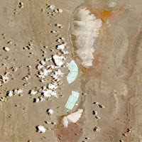 | | Lithium Mining in Argentina The bright green/cyan features in this Harmonized Landsat and Sentinel-2 image are evaporation ponds, with whitish salars (salt flats) to the north and south of the ponds. Lithium brine is pumped from the salars into the evaporation ponds. | | | | | | | | View more Images of the Week | | | | | |
| | | | | | NASA's Earth Science Data Systems (ESDS) Program oversees the life cycle of NASA’s Earth science data and seeks to maximize the scientific return from missions and experiments. | | | | | |
|
|
Digital Υπηρεσίες Επικοινωνίας
✍️ Content & άρθρα (news, social, πολιτική)
🎧 Transcription & μετατροπές κειμένων
📢 Copywriting για brands & υπηρεσίες
🌐 Blog setup & content management
📄 CV writing (Europass & σύγχρονα formats)
⌨️ Data entry & document formatting
📝 Πρακτικά & απομαγνητοφώνηση
📊 Market research & online insights
📞 6998069746
📧 webekdossis@gmail.com
Tι ήταν η ΕΦΗΜΕΡΙΔΑ «ΠΟΛΙΤΙΚΗ»..για όσους δεν γνωρίζουν.
Η «ΠΟΛΙΤΙΚΗ» γεννήθηκε το 2000,ως συνέχεια του Περιοδικού «ΑΧΑΡΝΕΩΝ Έργα». Δημιουργήθηκε από Επαγγελματίες Εκδότες με δεκαετίες στον τομέα της Διαφήμισης, των Εκδόσεων και των Δημοσίων Σχέσεων και αρχικά ήταν μια Υπερτοπική Εφημερίδα με κύριο αντικείμενο το Αυτοδιοικητικό Ρεπορτάζ.
Επί χρόνια, κυκλοφορούσε την έντυπη έκδοσή της σε ένα ικανότατο τιράζ (5000 καλαίσθητων φύλλων εβδομαδιαίως) και εντυπωσίαζε με την ποιότητα της εμφάνισης και το ουσιώδες, μαχητικό και έντιμο περιεχόμενο της.
Η δύναμη της Πένας της Εφημερίδας, η Ειλικρίνεια, οι Ερευνές της που έφερναν πάντα ουσιαστικό αποτέλεσμα ενημέρωσης, την έφεραν πολύ γρήγορα πρώτη στην προτίμηση των αναγνωστών και γρήγορα εξελίχθηκε σε Εφημερίδα Γνώμης και όχι μόνον για την Περιφέρεια στην οποία κυκλοφορούσε.
=Επι είκοσι έξι (26) χρόνια, στηρίζει τον Απόδημο Ελληνισμό, χωρίς καμία-ούτε την παραμικρή- διακοπή
.
=Επί είκοσι έξι ολόκληρα χρόνια, προβάλλει με αίσθηση καθήκοντος κάθε ξεχωριστό, έντιμο και υπεύθυνο Πολιτικό της Πολιτικής Σκηνής. Στις σελίδες της, θα βρείτε ακόμα και σήμερα μόνο άξιες και χρήσιμες Πολιτικές Προσωπικότητες αλλά και ενημέρωση από κάθε Κόμμα της Ελληνικής Βουλής. Η «ΠΟΛΙΤΙΚΗ» ουδέποτε διαχώρησε τους αναγνώστες της ανάλογα με τα πολιτικά τους πιστεύω. Επραττε το καθήκον της, ενημερώνοντας όλους τους Ελληνες, ως όφειλε.
=Επί είκοσι έξι ολόκληρα χρόνια, δίνει βήμα στους αδέσμευτους, τους επιτυχημένους, τους γνώστες και θιασώτες της Αλήθειας. Στηρίζει τον Θεσμό της Ελληνικής Οικογένειας, την Παιδεία, την Ελληνική Ιστορία, προβάλλει με όλες της τις δυνάμεις τους Αδελφούς μας απανταχού της Γης, ενημερώνει για τα επιτεύγματα της Επιστήμης, της Επιχειρηματικότητας και πολλά άλλα που πολύ καλά γνωρίζουν οι Αναγνώστες της.
=Επί είκοσι έξι ολόκληρα χρόνια, ο απλός δημότης–πολίτης, φιλοξενείται στις σελίδες της με μόνη προϋπόθεση την ειλικρινή και αντικειμενική γραφή και την ελεύθερη Γνώμη, η οποία ΟΥΔΕΠΟΤΕ λογοκρίθηκε.
Η ΕΦΗΜΕΡΙΔΑ «ΠΟΛΙΤΙΚΗ», είναι ένα βήμα Ισονομίας και Ισοπολιτείας, έννοιες απόλυτα επιθυμητές, ιδιαιτέρως στις ημέρες μας. Είναι ο δικτυακός τόπος της έκφρασης του πολίτη και της εποικοδομητικής κριτικής, μακριά από κάθε στήριξη αφού ΟΥΔΕΠΟΤΕ ετύγχανε οικονομικής υποστήριξης από Δήμους, Κυβερνήσεις ή όποιους άλλους Δημόσιους ή Ιδιωτικούς Φορείς, δεν είχε ΠΟΤΕ χορηγούς, ή οποιασδήποτε μορφής υποστηρικτές. Απολαμβάνει όμως Διεθνούς σεβασμού αφού φιλοξενεί ενημέρωση από αρκετά ξένα Κράτη πράγμα που της περιποιεί βεβαίως, μέγιστη τιμή.
Η ΕΦΗΜΕΡΙΔΑ «ΠΟΛΙΤΙΚΗ» διαγράφει απο την γέννησή της μια αξιοζήλευτη πορεία και απέκτησε εξ αιτίας αυτού,ΜΕΓΙΣΤΗ αναγνωσιμότητα.
Η Εφημερίδα «ΠΟΛΙΤΙΚΗ» κέρδισε την αποδοχή και τον σεβασμό που της ανήκει, με «εξετάσεις» εικοσι έξι ολόκληρων ετών, με συνεχείς αιματηρούς αγώνες κατά της τοπικής διαπλοκής, με αγώνα επιβίωσης σε πολύ δύσκολους καιρούς, με Εντιμότητα, αίσθηση Καθήκοντος και Ευθύνης.


Σχόλια
Δημοσίευση σχολίου
Eυπρόσδεκτα τα σχόλιά Σας...