| | | | | | | |  | | | | OPEN ACCESS FOR OPEN SCIENCE | APRIL 2023 |
| | | | | | | |
| | | | | | |  | | | | | | | | | | | | | | | | Two investigations—one using field campaigns, one using commercial smallsat data—are helping put the cycle in carbon cycle. | | | | | | | | | | | | | | | | The NASA-led Export Processes in the Ocean from Remote Sensing (EXPORTS) project investigates how organic carbon is biologically produced, processed, and stored in the depths of the ocean. | | | | | | | | | | | | | | | | Results from this research establish a framework for mapping carbon stocks at the level of individual trees at a sub-continental scale, help improve ecosystem models, and provide a tool for restoration efforts. | | | | | | | | | |
| | | | | | | April 22 is the global Earth Day celebration and NASA has you covered. NASA maintains one of the largest archives of Earth science data on the planet—all of which are fully and openly available. Start your explorations today! | Get Started | | | | | | |
| | | | |  | | Articles | | | | | |
| | | | | | |  | | Preparing for Oceans of Data
Careful calibration and validation ensure that the recently launched Surface Water and Ocean Topography (SWOT) mission will provide the best data possible. | | | | | | | |  | | Monitoring and Tracking
Tropospheric Ozone
Ozone is a two-edged sword: beneficial in Earth’s stratosphere, but harmful in the troposphere. Dr. Owen Cooper’s work using NASA Earth science data is shedding new light on the current—and future—state of this critical atmospheric component. | | | | | | | |  | | NASA Announces Pause in GEDI Mission
The Global Ecosystem Dynamics Investigation (GEDI) instrument has temporarily been moved to an alternate location on the International Space Station. GEDI will return to its original location and resume operations in 2024. | | | | | | | |  | | New Data Discoveries Added to VEDA Dashboard
Discoveries about fire, coastal risks from sea level rise, changes in the global water cycle, snowpack projections, and Houston heat are the newest additions to NASA’s Visualization, Exploration, and Data Analysis (VEDA) Dashboard. | | | | | | | |  | | Airborne and Field Data Workshop Report
The final report from the NASA Airborne and Field Data Workshop is now available. The report provides recommendations on how NASA can improve the ability for data producers and data users to meet NASA science objectives. | | | | | |
| | | | | |  | | Webinars | | | | | |
|
| | | | |  | | New Data | | | | | |
| | Mapping Global Agriculture The 30-meter Landsat-Derived Global Rainfed and Irrigated-Cropland Product (LGRIP) maps the world’s agriculture into rainfed and irrigated croplands. | | | | | | | | ABoVE Dataset for Alaska Vegetation The Alder Shrub Cover and Soil Properties, Alaska, 2019, NASA Arctic Boreal Vulnerability Experiment (ABoVE) dataset provides measurements for sites in interior Alaska along the James W. Dalton Highway. | | | | | | | | Tracking Global Salt Marsh Changes A NASA Carbon Monitoring System (CMS) dataset provides global salt marsh change at a 30-meter spatial resolution, including loss and gain for five-year periods from 2000-2019. | | | | | | | | Updated Sea Surface Salinity Data Sea surface salinity (SSS) is a vital component of ocean circulation. Updated SSS data products created from Soil Moisture Active Passive (SMAP) data fill a data need identified in the 2020 Satellite Needs Working Group survey. | | | | | | | | Jupyter Notebook for Plotting California Storms A Jupyter Notebook shows how to use Python to plot sea surface salinity anomalies over the ocean and precipitation over land to visualize the impact of recent severe storms over California. | | | | | | | | WindSat TOA Dataset A new global WindSat Top of the Atmosphere (TOA) Brightness Temperature dataset from Remote Sensing Systems (RSS) is available. The WindSat Polarimetric Radiometer was designed to measure ocean surface wind vectors from space. | | | | | | | | New RAMSES II Dataset A Level 2 Retrieval Algorithm for Microwave Sounders in Earth Science (RAMSES II) dataset provides the retrieval of all-sky temperature and humidity profiles in the presence of clouds. | | | | | | | | Sentinel-5 Precursor (S5P) Full Mission Reprocessed Datasets Full mission data of variables derived from Tropospheric Monitoring Instrument (TROPOMI) observations for all Level 1B products and Level 2 methane, nitrogen dioxide, and aerosol layer height products are available. | | | | | | | | Tracking Global Migration Patterns The new Groundswell Spatial Population and Migration Projections dataset helps show how slow-onset climate change might affect internal migration in low- to middle-income countries in the coming decades. | | | | | | | | Global Natural Resource Protection and Child Health Indicators The Natural Resource Protection Indicator (NRPI) is based on biomes under protected status. The Child Health Indicator (CHI) is a composite index derived from scores for access to at least basic water and sanitation, along with child mortality. | | | | | | | | SAR Products Available for Recent Earthquakes Synthetic Aperture Radar (SAR) data products acquired over the area of the recent Turkey/Syria earthquakes are now freely available from the Japan Aerospace Exploration Agency. | | | | | |
| | | | | |  | | Open Science | | | | | |
| | | | | |  | | Connect with NASA Earth Science | | | | | |
| | The following meetings and conferences feature NASA Earth science data and many include participation by NASA Earth science data creators and providers. This is a great opportunity to meet the people behind the data. | | | | | | | | European Geosciences Union (EGU) General Assembly 2023 Date: April 23-28 Location: Vienna, Austria/Virtual | | | | | | | | U.S. Forest Service-NASA Joint Applications Workshop: Addressing Land & Water Monitoring Needs Using Remote Sensing Data Date: April 25-27 Location: Salt Lake City, UT/Virtual | | | | | | | | Japan Geoscience Union Meeting 2023 Date: May 21-26 Location: Chiba City, Japan/Virtual | | | | | | | | American Astronomical Society Date: June 4-8 Location: Albuquerque, NM/Virtual | | | | | | | | American Library Association Annual Conference and Exhibition Date: June 22-27 Location: Chicago, IL/Virtual | | | | | | | | International Union of Geodesy and Geophysics (IUGG) Date: July 11-20 Location: Berlin, Germany | | | | | | | | International Geoscience and Remote Sensing Symposium (IGARSS) Date: July 16-21 Location: Pasadena, CA | | | | | | | | Earth Science Information Partners (ESIP) Summer Meeting Date: July 18-21 Location: Burlington, VT | | | | | | | | Asia Oceania Geosciences Society (AOGS) Annual Meeting Date: July 30-August 4 Location: Singapore | | | | | | | | Optica Sensing Congress Date: July 30-August 3 Location: Munich, Germany/Virtual | | | | | | | | Ecological Society of America (ESA) Annual Meeting Date: August 6-11 Location: Portland, OR | | | | | | | | American Chemical Society Fall Meeting Date: August 13-17 Location: San Francisco, CA/Virtual | | | | | |
| | | | | |  | | Worldview Images of the Week | | | | | |
| |  | | Flooding in Mozambique and Malawi Torrential rain (between 8 and 26 inches in just over two days) from the long-lived Tropical Cyclone Freddy led to extensive flooding and landslides in the neighboring countries of Mozambique and Malawi in Southeastern Africa. | | | | | | | | 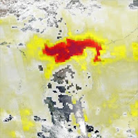 | | High Aerosol Index over Laos and Vietnam Fires in Southeast Asia led to high concentrations of atmospheric dust and soot, which are shown in red colors. The Aerosol Index indicates concentrations of aerosols that could reduce visibility or impact human health. | | | | | | | | View more Images of the Week | | | | | |
| | | | | | NASA's Earth Science Data Systems (ESDS) Program oversees the life cycle of NASA’s Earth science data and seeks to maximize the scientific return from missions and | |
|
|
 | NASA8800 Greenbelt Rd.Greenbelt, MD 20771 |
|
|
|
|