| | | | | | | |  | | | | OPEN ACCESS FOR OPEN SCIENCE | JANUARY 2024 |
| | | | | | | |
| | | | | | |  | | | | | | | | | | | | | | | | The joint NASA/ESA Multi-Mission Algorithm and Analysis Platform (MAAP) was featured at the UN Climate Change Conference (COP28) as part of the Global Stocktake (GST). The platform is designed to support collaborative research in a common cloud environment. | | | | | |
| | | | | | | The Biomass Earthdata Dashboard, powered by MAAP, plays a key role in assessing global biomass stocks. | Explore Biomass Data | | | | | | |
| | | | |  | | Articles | | | | | |
| | | | | | |  | | Living in Heat that Kills
Every summer, up to 600 people die in Miami-Dade County, FL, from extreme heat exposure. A NASA-funded initiative incorporating data from NASA’s Earth science collection is helping the county better protect vulnerable residents. | | | | | | | |  | | Making SAR Data Easier to Use
Two new analysis-ready synthetic aperture radar (SAR) products created by NASA’s Observational Products for End-Users from Remote Sensing Analysis (OPERA) project reduce the time and technical barriers to using SAR observations. | | | | | | | |  | | From Petabytes to Insights: Tackling Earth Science’s Scaling Problem
IMPACT Project Manager Dr. Rahul Ramachandran was selected for the 2023 Greg Leptoukh Lecture Award. The lecture recognizes notable contributions in informatics and data science that enable scientific discoveries. The talk is virtual on the Earthdata website. | | | | | | | |  | | Entering the Second Decade of OCO-2 Data
Since 2014, NASA’s Orbiting Carbon Observatory-2 (OCO-2) has acquired high-resolution atmospheric carbon dioxide (CO2) observations with unprecedented accuracy. These data show the unambiguous increase in global CO2 levels. | | | | | | | | 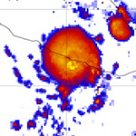 | | Hurricane Otis by the Numbers
Many factors caused Hurricane Otis to intensify to a monster Category 5 storm in 24 hours before bringing howling winds and driving rain to Acapulco, Mexico. A Data in Action article explores the data behind the storm’s rapid intensification. | | | | | | | | 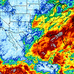 | | A Month of Precipitation Contrasts
An examination of Integrated Multi-satellitE Retrievals for GPM (IMERG) data for December 2023 shows the dramatic contrast in U.S. precipitation between the heavy rain along both coasts and the relatively dry interior of the country. | | | | | | | | 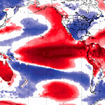 | | Summer 2023 in Review and a Look at the Upcoming Winter
NASA data enable a look back at a very warm Northern Hemisphere summer and a look forward at what the upcoming winter might hold, including the influence of El Niño. | | | | | | | |  | | The Tools Behind Snow Data
The 2023 winter brought record snow to parts of the western U.S. Getting accurate snow depth data over a wide area is not easy. Learn more about the challenges of acquiring snow data and the tools behind these data. | | | | | |
| | | | | |  | | Webinars & Events | | | | |
| | | | | | | Earthdata Search Webinar January 24, 2024 | | | | | | | | Whether you are an experienced Earthdata Search user or are just getting started, this webinar will show you how to search for, discover, and access Earth science data using Earthdata Search. | |
| | | | | | GPM 10-in-10 Webinar Series To celebrate the 10-year anniversary of the Global Precipitation Measurement (GPM) mission’s launch, the GPM team is hosting 10 webinars in 2024 focusing on precipitation measurement from space. The first webinar takes place Thursday, February 8.
| | | |
| | | | |  | | New Data, Tutorials, & Resources | | | | | |
| | NASA Earth Science Data Roundup Read summaries of data, products, and resources released by NASA’s Distributed Active Archive Centers (DAACs) over the past month. | | | | | | | | Data Tool in Focus: OpenAltimetry From studies of land elevation to changes in water level, OpenAltimetry enables users to work with large volumes of satellite laser altimetry data from NASA’s Ice, Cloud, and land Elevation Satellite (ICESat) and ICESat-2 missions. | | | | | |
| | | | | |  | | Open Science | | | | | |
| | | | | |  | | Connect with NASA Earth Science | | | | | |
| | | | | |  | | Worldview Images of the Week | | | | | |
| | 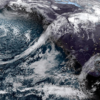 | | Atmospheric River Drenches the Pacific Northwest An early-December atmospheric river delivered warm, wet weather to much of the U.S. states of Washington and Oregon, toppling daily rainfall and temperature records and escalating flood and debris flow risks. | | | | | | | | 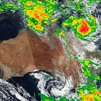 | | Tropical Cyclone Jasper Tropical Cyclone Jasper is the first tropical storm of the season to hit Australia. The storm brought winds of more than 85 miles per hour and rainfall rates around 0.5 inches/hour to the northeast corner of the country. | | | | | | | | 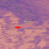 | | Iceland Volcano Erupts After weeks of earthquakes, lava began flowing from a fissure near the town of Grindavik on the Reykjanes Peninsula of Iceland near the capital of Reykjavik. The red area in this image is the lava heat signature. | | | | | | | | 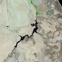 | | Toshka Lakes, Egypt The Toshka Lakes appear due to periodic overflow of Lake Nasser in Egypt. Heavy rainfall in Sudan and South Sudan in the summer of 2019 and major flooding events in Sudan in 2020, 2021, and 2022 refilled the lakes. | | | | | | | | View more Images of the Week | | | | | |
| | | | | | NASA's Earth Science Data Systems (ESDS) Program oversees the life cycle of NASA’s Earth science data and seeks to maximize the scientific return from missions and experiments. | | | | | |
| |
|
|