|
|

EARTHDATA DISCOVERY
OPEN ACCESS FOR OPEN SCIENCE | OCTOBER 2023

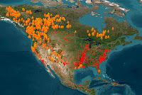
NASA-Funded Project Aids Maui Fire Recovery
A project funded under the Advancing Collaborative Connections for Earth System Science (ACCESS) program created fire maps with 3-meter resolution that are aiding the recovery from the devastating wildfires that swept through Maui in August.
NASA provides unrestricted access to a wide range of wildfire data and resources. Start Exploring
| | |
| | | | |  | | Articles | | | | | |
|
| | | | | |  | | Weather Ballooning from Space
Like weather balloons, radio occultation data from navigation satellites provide valuable information about temperature, pressure, and other constituents in the atmosphere. A NASA-funded project is creating an open repository of these data. | | | | | | | |  | | Applying AI to Weather and Climate Data
A collaborative effort involving NASA’s Interagency Implementation and Advanced Concepts Team (IMPACT) is applying AI to weather and climate data to create an AI Foundation Model. | | | | | | | |  | | Visualize and Explore Surface Elevation Data with OpenAltimetry
OpenAltimetry provides cloud-based access for searching for and working with data from NASA’s Ice, Cloud, and Land Elevation Satellite-2 (ICESat-2). Data from ICESat are scheduled to be added in November. | | | | | | | |  | | Tracking Ocean Salinity
Sea surface salinity is constantly changing. These changes affect not just ocean processes, but the entire water cycle. Using NASA Earth science data, Dr. Frederick Bingham explores changes in global ocean salinity and the impacts of these changes. | | | | | | | |  | | A Close Look at Sea Surface Height
A new model simulation shows high-resolution features in ocean surface topography. These features are not resolved by current altimeters but are captured by NASA’s Surface Water and Ocean Topography (SWOT) satellite. | | | | | | | |  | | Shishaldin Volcano Erupts
The Shishaldin Volcano in Alaska’s Aleutian Islands had an explosive eruption in August. Sulfur dioxide (SO2) emissions from the volcano were observed by the Ozone Measuring Instrument (OMI) aboard NASA’s Aura satellite in August and September. | | | | | | | | 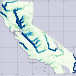 | | Watching Snow Melt in California with NLDAS
Snowmelt from the heavy 2022-2023 California snow season filled lakes, streams, and rivers. A Data in Action article shows how data from the North American Land Data Assimilation System (NLDAS) provided a month-by-month record of this melting. | | | | | |
| | | | | |  | | Webinars & Events | | | | | |
|
| | | | | | Watch it Again: GUARDIAN Learn how the Global Navigation Satellite System (GNSS)-based Upper Atmospheric Realtime Disaster Information and Alert Network (GUARDIAN) software provides early warning of atmospheric changes that can indicate natural disasters.
View Event Recording | |  | | | | | | | | ACTIVATE Data Workshop November 13-15, 2023 NASA’s Aerosol Cloud Meteorology Interactions Over the Western Atlantic Experiment (ACTIVATE) science team is hosting a free open data workshop at the University of Arizona (Tucson, Arizona). Participants can attend virtually or in person.
Register for Workshop | |  | | | | | | | | Searching and Accessing NASA Earthdata with Python November 14, 2023 This hands-on session hosted by The Carpentries is geared toward Python data users who are new to NASA Earthdata. Learn how to navigate the Earthdata website as well as how to find data and resources through Earthdata Data Pathfinders.
Register for Session | |  | | | | | |
| | | | |  | | New Data, Tutorials, & Resources | | | | | |
| | NASA Earth Science Data Roundup This feature provides a summary of data, products, and resources released by NASA’s Distributed Active Archive Centers (DAACs) over the past month. | | | | | | | | Data Tool in Focus: SeaDAS The Sea, Earth, and Atmosphere Data Analysis System (SeaDAS) provides access to ocean color, ocean biology, and similar data. | | | | | | | | Full HLS Archive Now Available The Harmonized Landsat and Sentinel-2 team has completed historical processing of the entire HLS data archive. Landsat-based imagery is available from 2013 to present and Sentinel-based imagery is available from 2015 to present. | | | | | | | | New Tool Added to MAAP The latest addition to the Multi-Mission Algorithm and Analysis Platform (MAAP) tool box enables users to make interactive maps in a Jupyter notebook, mixing data published in the MAAP Spatial Temporal Asset Catalogs (STAC) with users’ local data. | | | | | | | | Worldview’s Embed Mode is Back After being unavailable since December 2022, Worldview users can once again embed imagery on websites to enhance interactive data exploration. Read more in a recent Global Imagery Browse Services (GIBS) Blog. | | | | | | | | New Feature in Worldview A new feature in NASA Worldview enables users to toggle on/off classifications that were previously hidden as transparent pixel values. Learn more about this feature in a GIBS Blog. | | | | | | | | OPERA Jupyter Notebook Tutorials The tutorials show how to search for, visualize, and mosaic Observational Products for End-Users from Remote Sensing Analysis (OPERA) project surface water extent data over the Lake Powell Reservoir before and after the summer of 2023. | | | | | | | | Popular Maxar Commercial Satellite Data Collections Now in Earthdata Search NASA’s Commercial Smallsat Data Acquisition (CSDA) program is enabling some Maxar collections to be discoverable in Earthdata Search. All users can browse CSDA collections in Earthdata Search; approved users can download these data. | | | | | |
| | | | | |  | | Open Science | | | | | |
| | | | | |  | | Making Earth Science Data FAIR Data that can’t be found can’t be used. NASA efforts to make data Findable, Accessible, Interoperable, and Reusable (FAIR) are making NASA Earth science data easier to use for both people and machines. | | | | | | | |  | | TOPS Open Science 101
Pre-Registration OpenOpen Science 101 is a NASA Transform to Open Science (TOPS) five-module training designed to equip participants with the knowledge and skills to navigate the principles and practices of open science. The training is scheduled to launch in December. | | | | | |
| | | | | |  | | Connect with NASA Earth Science | | | | | |
| | The NASA Booth and NASA Earth science data creators, managers, and providers are at conferences you might be attending. These are great opportunities to connect with the people behind the data. | | | | | | | | Geological Society of America (GSA) Connects 2023 Date: October 15-18 Location: Pittsburgh, PA | | | | | | | | NASA Health and Air Quality Applied Sciences Team (HAQAST) Public Meeting Date: October 19-20 Location: Salt Lake City, UT | | | | | | | | American Indian Science and Engineering Society National Conference Date: October 19-21 Location: Spokane, WA | | | | | | | | FedGeoDay Date: October 23 Location: Baltimore, MD | | | | | | | | 2023 Accelerating Space Commerce, Exploration, and New Discovery (ASCEND) Date: October 23-25 Location: Las Vegas, NV | | | | | | | | International Data Week’s SciDataCon 2023 Date: October 23-26 Location: Salzburg, Austria/Virtual | | | | | | | | World Climate Research Programme Open Science Conference Date: October 23-27 Location: Kigali, Rwanda/Virtual | | | | | | | | Energy Data Analytics Symposium Date: October 26-27 Location: Durham, NC | | | | | | | | National Diversity in STEM (NDiSTEM) Conference 2023 Date: October 26-28 Location: Portland, OR | | | | | | | | Big Data from Space 2023 (BiDS) Date: November 6-9 Location: Vienna, Austria | | | | | | | | National Society of Black Physicists (NSBP) Annual Conference Date: November 9-12 Location: Knoxville, TN/Virtual | | | | | | | | American Society for Gravitational and Space Research (ASGSR) Annual Meeting Date: November 14-18 Location: Washington, D.C. | | | | | | | | United Nations Climate Change Conference (COP 28) Date: November 30-December 12 Location: United Arab Emirates | | | | | | | | American Geophysical Union (AGU) Fall Meeting Date: December 11-15 Location: San Francisco, CA/Virtual | | | | | | | | American Meteorological Society (AMS) Annual Meeting Date: January 28 - February 1 Location: Baltimore, MD/Virtual | | | | | |
| | | | | |  | | Worldview Images of the Week | | | | | |
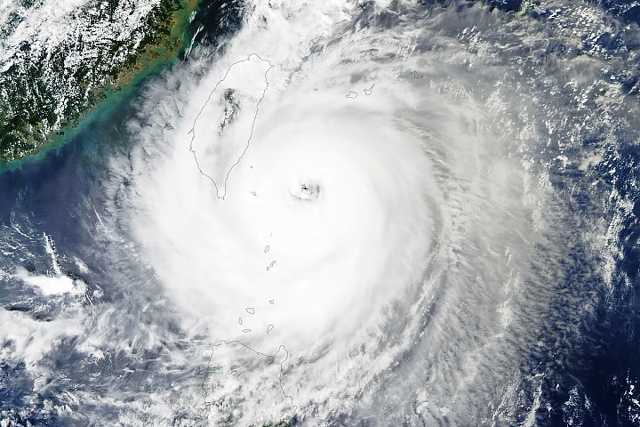
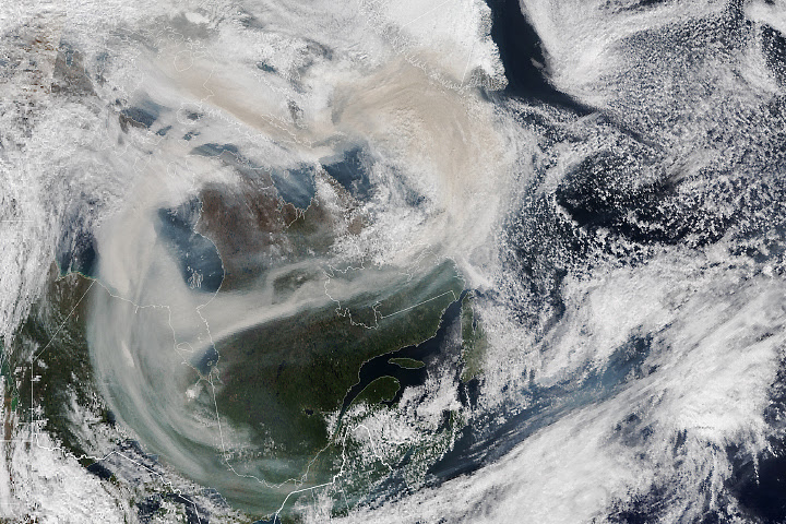
| | 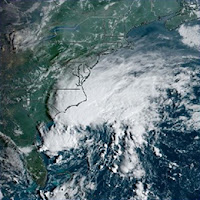 | | Powerful East Coast Storm Tropical Storm Ophelia moved up the U.S. East Coast in mid-September, bringing high wind and torrential rain. This image shows the storm off the North Carolina coast just before it reached tropical storm strength. | | | | | | | | 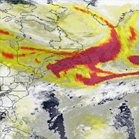 | | Wildfire Smoke Moves East Red areas in this image indicate high Aerosol Index values caused by Canadian wildfires. Smoke is traveling over the Atlantic Ocean. More than 6,400 fires have occurred across Canada that have burned almost 43,500,000 acres so far this year. | | | | | | | | View more Images of the Week | | | | | |
| | | | | | NASA's Earth Science Data Systems (ESDS) Program oversees the life cycle of NASA’s Earth science data and seeks to maximize the scientific return from missions and experiments. |
|


OCTOBER 10, 2023
Weekly News

LATEST IMAGES OF THE DAY
view the archive  Warm Autumn Hues on Kodiak Island
The Alaskan tundra puts on a fleeting display of color before the snows fall and bears hibernate.
 Lake Urmia Shrivels Again
A few years after a fresh influx of water raised its levels, the large lake has nearly gone dry.
 Indigenous Communities Protect the Amazon
Indigenous people are protecting carbon-rich forests in South America, and satellites are helping.
 Beneath a Desert Moon
An oblique-angle photo taken from above the Middle East captures the Moon peeking over Earth's atmospheric limb.
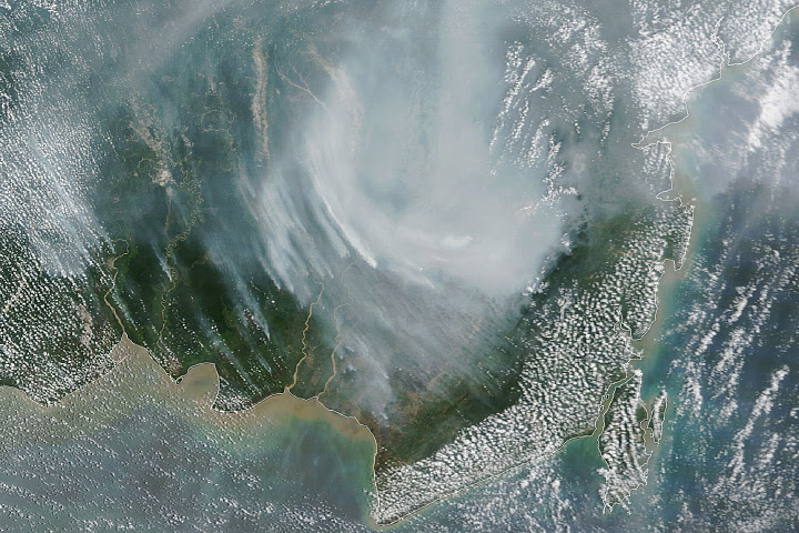
 Indonesian Fires Return in 2023
Dry conditions brought on by El Niño likely intensified the 2023 fire season, following several years of relative quiet.
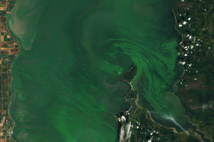
 Emerald Swirls of Algae in Lake Winnipeg
An influx of nutrients in recent decades has contributed to the proliferation of algae in the large Canadian lake.
|
|
 | NASA8800 Greenbelt Rd.Greenbelt, MD 20771 |
|
|
| | |
| |
|
|
| | | |
|