| | | | | | | |  | | | | OPEN ACCESS FOR OPEN SCIENCE | AUGUST 2023 |
| | | | | | | |
| | | | | | |  | | | | | | | | | | | | | | | | The State of the Ocean (SOTO) tool makes it easy to visualize physical oceanography data products centered on three parameters: chlorophyll a, sea surface temperature, and sea surface temperature anomaly. | | | | | |
| | | | |  | | Articles | | | | | |
| | | | | | |  | | Putting the FUN in Funding
Thanks to a spark from Earth Science Information Partners’ (ESIP) FUNding Friday, a NASA/Rensselaer Polytechnic Institute collaboration is teaching students how to create apps using Earth observation data—and how to use these data ethically. | | | | | | | |  | | Taking a Closer Look at...Us
Dr. Dan Runfola uses NASA Earth science data to explore the socioeconomic status of individuals around the globe. | | | | | | | | 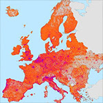 | | Measuring Global Relative Poverty and Deprivation
The Global Gridded Relative Deprivation Index, Version 1 (GRDIv1) offers measures of relative poverty and deprivation at a higher resolution and using more inputs than other multidimensional poverty datasets. | | | | | | | |  | | Monitoring Development of El Niño Conditions
Data show that conditions in the Pacific Ocean are turning more favorable for the development of El Niño conditions this winter. A Data in Action article highlights what the data are indicating. | | | | | | | | 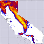 | | Comparing Snowfall Products for the 2022-2023 California Snow Season
A new Data in Action article compares snow data products from the North American Land Data Assimilation System (NLDAS) with weather station and ground measurements of the immense snowfall totals in the California mountains in 2022-2023. | | | | | | | |  | | Flooding in Vermont
Atmospheric circulation patterns delivered torrential rains to southern Vermont and adjacent states in July 2023. A Data in Action article uses model output data to examine why the flooding rainfall impacted Vermont valley towns. | | | | | | | |  | | Canadian Wildfire Air Pollution in the U.S.
Data from NASA’s TRopospheric Ozone and Precursors from Earth System Sounding (TROPESS) project were used to examine carbon monoxide levels in Canadian wildfire smoke that impacted air quality in the Northeastern United States. | | | | | |
| | | | | |  | | Webinars & Events | | | | | |
| | |  | | | | | | | | Watch it Again: Demystifying the Cloud | | | | Working with cloud-based data can seem daunting, but it doesn’t need to be! This webinar demonstrates workflows for accessing cloud-based snow and ice data at NASA’s National Snow and Ice Data Center Distributed Active Archive Center (NSIDC DAAC). | | | | | | | | View Event Recording | | | | | |
| | From Ocean to Cloud—Enabling Workflows and Data Utilization August 23, 2023 NASA’s Physical Oceanography DAAC (PO.DAAC) will discuss recent experiences migrating code and workflows for generating oceanography datasets to the cloud and showcase a new cloud tutorial.
Register for Webinar | |  | | | | | | | |  | | CASEI—Empowering Access to Airborne and Field Investigation Data
August 30, 2023 Learn how to use the new Catalog of Archived Suborbital Earth Science Investigations (CASEI) to find campaign, platform, and instrument information for NASA-funded suborbital investigations.
Register for Webinar | | | | | | | | UNBOUND CI September 18, 19, 25, and 26, 2023 The Understanding Needs to Broaden Outside Use of NASA Data for Coastal Issues (UNBOUND CI) workshop aims to enhance awareness, accessibility, and utilization of NASA Earth science data for coastal applications, and is limited to 60 participants.
Apply for Workshop | |  | | | | | | | |  | | ESIP Summer Meeting Highlights Webinar August 23, 2023 A lot was discussed at the ESIP Summer Meeting in July! This webinar presents highlights and report-outs from various sessions, including major takeaways, next steps, and how you can get involved.
Register for Webinar | | | | | | | | | | | | PACE Applications Workshop September 6-7, 2023 The NASA Plankton, Aerosol, Cloud, ocean Ecosystem (PACE) Applications Team invites the research, applied sciences, and decision-making communities to the virtual 2023 PACE Applications Workshop.
Register for Workshop | |  | | | | | |
| | | | |  | | New Data, Tutorials, & Resources | | | | | |
| | NASA Earth Science Data Roundup This feature provides a summary of data, products, and resources released by NASA’s Distributed Active Archive Centers (DAACs) over the past month. | | | | | |
| | | | | |  | | Open Science | | | | | |
| | | | | |  | | Help Shape the Future of Open Science The Open Geospatial Consortium (OGC) is building a collaborative open science environment called the Open Science Persistent Demonstrator (OSPD) and wants your help. Learn how you can be involved in this global, multi-agency effort. | | | | | | | |  | | TOPS Community Forum The next Transform to Open Science (TOPS) Community Forum takes place September 14, at 1 p.m., EDT [UTC -4]. Sign up to receive email alerts about upcoming TOPS Forums and other NASA open science events. | | | | | |
| | | | | |  | | Connect with NASA Earth Science | | | | | |
| | The NASA Booth and NASA Earth science data creators, managers, and providers are at conferences you might be attending. These are great opportunities to connect with the people behind the data. | | | | | | | | American Chemical Society Fall Meeting Date: August 13-17 Location: San Francisco, CA/Virtual | | | | | | | | NASA Open-Source Science Data Repositories Workshop Date: September 27-29 Location: Boulder, CO/Virtual | | | | | | | | NASA International Space Apps Challenge Date: October 7-8 Location: Global Locations/Virtual | | | | | | | | Association of Science and Technology Centers (ASTC) Annual Conference Date: October 7-10 Location: Charlotte, NC | | | | | | | | Albuquerque International Balloon Fiesta Date: October 7-15 Location: Albuquerque, NM | | | | | | | | Society of Asian Scientists and Engineers National Convention Date: October 11-14 Location: Atlanta, GA | | | | | | | | 9th Annual Historically Black Colleges and Universities (HBCU) Climate Change Conference Date: October 11-15 Location: New Orleans, LA | | | | | | | | Geological Society of America (GSA) Connects 2023 Date: October 15-18 Location: Pittsburgh, PA | | | | | | | | NASA Health and Air Quality Applied Sciences Team (HAQAST) Public Meeting Date: October 19-20 Location: Salt Lake City, UT | | | | | | | | American Indian Science and Engineering Society National Conference Date: October 19-21 Location: Spokane, WA | | | | | | | | 2023 Accelerating Space Commerce, Exploration, and New Discovery (ASCEND) Date: October 23-25 Location: Las Vegas, NV | | | | | | | | International Data Week’s SciDataCon 2023 Date: October 23-26 Location: Salzburg, Austria/Virtual | | | | | | | | World Climate Research Programme Open Science Conference Date: October 23-27 Location: Kigali, Rwanda/Virtual | | | | | | | | National Diversity in STEM (NDiSTEM) Conference 2023 Date: October 26-28 Location: Portland, OR | | | | | |
| | | | | |  | | Worldview Images of the Week | | | | | |
| |  | | Blowing Dust and Salt in Namibia There’s a lot going on this Worldview image! Light brown dust can be seen blowing off the coast of Namibia. In northern Namibia, whitish salt is blowing from the Etosha Pan. Further inland, in Botswana, greyish white smoke from fires can be seen. | | | | | | | |  | | Fires in Rhodes, Greece Fires raged across Greece during July, including these blazes on the island of Rhodes. Nearly 20,000 people have been forced to evacuate throughout the country, according to the Greek Ministry of Climate Change and Civil Protection. | | | | | | | | View more Images of the Week | | | | | |
| | | | | | NASA's Earth Science Data Systems (ESDS) Program oversees the life cycle of NASA’s Earth science data and seeks to maximize the scientific return from missions and experiments. |
|
|
|
