| | | | | | | |  | | | | OPEN ACCESS FOR OPEN SCIENCE | JULY 2023 |
| | | | | | | |
| | | | | | |  | | | | | | | | | | | | | | | | Along with a constellation of orbiting satellites, NASA maintains a fleet of aircraft ranging from stratosphere-skirting piloted ships to unmanned aerial vehicles. Airborne data are a key component of the agency’s Earth science data collection. | | | | | |
| | | | | | | The Earthdata Air Quality Data Pathfinder is your gateway to data, tools, and resources for exploring the air up there. | Start Exploring Today! | | | | | | |
| | | | |  | | Articles | | | | | |
| | | | | | |  | | Investigating the Impact of Aerosols on Climate
Tiny suspended particles in the atmosphere pack a big punch when it comes to impacts on Earth’s climate. NASA Earth science data help Dr. Eric Wilcox investigate the role of aerosols and clouds in absorbing and scattering sunlight. | | | | | | | |  | | Making NASA Air Quality Data Easier to Use
Attendees at a recent series of workshops provided valuable input about making NASA air quality data easier to use—and we’re listening. Read the workshop report and visit the updated Air Quality Data Pathfinder to learn more. | | | | | | | |  | | Data Under the Waves
Some data can’t be collected using satellite-borne sensors. NASA’s SeaWiFS Bio-optical Archive and Storage System (SeaBASS) helps fill in these data gaps by providing in situ data for satellite validation, algorithms, and open science. | | | | | | | |  | | An In-Depth Look at Super Typhoon Mawar
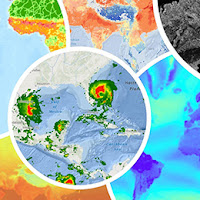
Super Typhoon Mawar was one of the strongest Northern Hemisphere typhoons ever observed in the month of May and brought heavy rain and high wind to Guam. A new article examines a variety of data related to this storm. | | | | | | | |  | | Why Italy Was Soaked this Spring
Italy experienced heavy spring flooding and torrential rain. A recent article examines the causes of this deluge in the context of continental-scale precipitation and the past two decades of satellite observations. | | | | | | | |  | | Tearing Down Technical Barriers
New surface water extent and surface disturbance products from a NASA-led effort are providing needed resources to federal agencies. | | | | | | | | 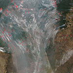 | | Monitoring Wildfires in Brazil
Atmospheric chemistry data from NASA’s TRopospheric Ozone and its Precursors from Earth System Sounding (TROPESS) Project are being used to examine emissions from August 2022 wildfires in Brazil. | | | | | | | |  | | Data Tool in Focus: TESViS
The Terrestrial Ecology Subsetting and Visualization Services (TESViS, formerly known as the MODIS/VIIRS Subsets Tool) is a suite of integrated tools and services that simplifies work with satellite and model-produced data products. | | | | | | | |  | | From Data entry to Digging Snow Pits
Data management team members exchanged desks for winter parkas in March 2023 to support NASA’s SnowEx 2023 field campaign and get “a crash course in snow science.” Their field work provided valuable context to the data they were stewarding. | | | | | |
| | | | | |  | | Webinars & Events | | | | | |
| | |  | | | | | | | | PACE Applications Workshop September 6-7, 2023 | | | | | | | | The NASA Plankton, Aerosol, Cloud, ocean Ecosystem (PACE) Applications Team invites the research, applied sciences, and decision-making communities to the virtual 2023 PACE Applications Workshop September 6-7, 2023, at 10:00 a.m., EDT. | | | | | | | | Register for Workshop | | | | | | | | | |
| | | | |  | | New Data, Tutorials, & Resources | | | | | |
| | NASA Earth Science Data Roundup This feature provides a summary of data, products, and resources released by NASA’s Distributed Active Archive Centers (DAACs) over the past month. | | | | | | | | OPERA Surface Water Extent Provisional Data Now Available The Observational Products for End-Users from Remote Sensing Analysis (OPERA) Level-3 Dynamic Surface Water Extent (DSWx) from Harmonized Landsat Sentinel-2 (HLS) provisional product (Version 1) dataset has been released. | | | | | | | | Projecting Future Climate-Related Migration in Africa The Groundswell Africa dataset provides alternative scenarios of population distribution and internal migration stemming from projected impacts of climate change in West Africa and the Lake Victoria Basin projected from 2010 to 2050. | | | | | | | | MERRA-2 Wind Speed A new data recipe shows how to calculate and plot wind speed using Modern-Era Retrospective Analysis for Research and Applications-2 (MERRA-2) wind component data in Python. | | | | | | | | Tutorial for Working with GeoTIFF Files A new Jupyter Notebook tutorial shows how to programmatically access Making Earth Science Data Records for Use in Research Environments (MEaSUREs) GeoTIFF files and perform Python-based geospatial operations to plot and combine multiple files. | | | | | | | | Updated VIIRS Dataset Landing Pages Updated landing pages for the Visible Infrared Imaging Radiometer Suite (VIIRS) Level 1 Calibrated Radiances and Geolocation and for the Level-3 Nighttime Lights products are available. | | | | | |
| | | | | |  | | Open Science | | | | | |
| | | | | |  | | Funding Opportunity | | | | | |
| | | | | |  | | Connect with NASA Earth Science | | | | | |
| | The NASA Booth and NASA Earth science data creators, managers, and providers are at conferences you might be attending. These are great opportunities to connect with the people behind the data. | | | | | | | | International Geoscience and Remote Sensing Symposium (IGARSS) Date: July 16-21 Location: Pasadena, CA | | | | | | | | Optica Sensing Congress Date: July 30-August 3 Location: Munich, Germany/Virtual | | | | | | | | Asia Oceania Geosciences Society (AOGS) Annual Meeting Date: July 30-August 4 Location: Singapore | | | | | | | | Ecological Society of America (ESA) Annual Meeting Date: August 6-11 Location: Portland, OR | | | | | | | | American Chemical Society Fall Meeting Date: August 13-17 Location: San Francisco, CA/Virtual | | | | | | | | Association of Science and Technology Centers (ASTC) Annual Conference Date: October 7-10 Location: Charlotte, NC | | | | | | | | Albuquerque International Balloon Fiesta Date: October 7-15 Location: Albuquerque, NM | | | | | | | | Geological Society of America (GSA) Connects 2023 Date: October 15-18 Location: Pittsburgh, PA | | | | | | | | NASA Health and Air Quality Applied Sciences Team (HAQAST) Public Meeting Date: October 19-20 Location: Salt Lake City, UT | | | | | | | | World Climate Research Programme Open Science Conference Date: October 23-27 Location: Kigali, Rwanda/Virtual | | | | | | | | 2023 Accelerating Space Commerce, Exploration, and New Discovery (ASCEND) Date: October 23-25 Location: Las Vegas, NV | | | | | | | | National Diversity in STEM (NDiSTEM) Conference 2023 Date: October 26-28 Location: Portland, OR | | | | | |
| | | | | |  | | Worldview Images of the Week | | | | | |
| |  | | Fires Burning Across Canada As of June 14, 2023, 2,619 fires in Canada have burned approximately 13 million acres. Both figures are far above the 10-year average for mid-June of 1,926 fires and approximately 818,000 acres burned. | | | | | | | | 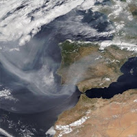 | | Canadian Wildfire Smoke Reaches Europe Carried by prevailing winds, smoke from raging wildfires in Canada traveled across the Atlantic Ocean and were impacting areas in Portugal and Spain by the end of June. | | | | | | | | 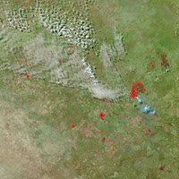 | | Fires in Botswana The peak fire season in Botswana typically begins in mid-August and lasts around 13 weeks. Between June 13, 2022, and June 12, 2023, there were 13,465 Visible Infrared Imaging Radiometer Suite (VIIRS) fire alerts, according to Global Forest Watch. | | | | | | | | View more Images of the Week | | | | | |
| | | | | | NASA's Earth Science Data Systems (ESDS) Program oversees the life cycle of NASA’s Earth science data and seeks to maximize the scientific return from missions and experiments. | | | | | |
| |
|
|