| | | | |  | | New Data, Tutorials, & Resources | | | | | |
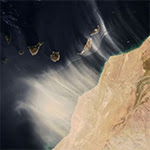
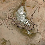
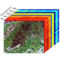
| | June Earth Science Data Roundup A roundup of datasets, resources, and other products released by NASA’s Distributed Active Archive Centers (DAACs) in May. | | | | | | | | SOTO by Worldview The updated State of the Ocean (SOTO) is powered by NASA Worldview and based on a cloud-native implementation. SOTO by Worldview includes many of the same features users are accustomed to, in addition to many new features. | | | | | | | | Indian Ocean Sea Surface Temperature A new data animation derived from the Spinning Enhanced Visible and InfraRed Imager (SEVIRI) instrument shows Indian Ocean sea surface temperature. | | | | | | | | Flood Mapping Tool for New York State Released A new mapping tool enables users to visualize critical infrastructure and building footprints for most of New York State in support of flood planning and response. | | | | | | | | ICESat-2 Jupyter Notebook Tutorial A new Ice, Cloud and land Elevation Satellite-2 Jupyter Notebook tutorial has guidance on how to search, access, and plot ATL06 data using the earthaccess Python library, and can be executed in-place in the cloud or via download to a local machine. | | | | | | | | EMIT Data Tutorials Videos of three EMIT data tutorial workshops are available on the NASA Earthdata YouTube channel. | | | | | | | | New Nitrogen Dioxide (NO2) Dataset NASA’s Health And Air Quality Applied Sciences Team has created a 1 km global surface-level NO2 dataset for the years 1990, 1995, 2000, and 2005-2020. The dataset fuses NO2 data from the Ozone Monitoring Instrument with a land-use regression model. | | | | | | | | Assessing Particulate Matter New Surface PM2.5 Composition Data Products from the Hazardous Air Quality Ensemble System (HAQES) developed by the Air Quality Laboratory at George Mason University are available. | | | | | | | | Tracking Smoke from Canadian Wildfires In early May 2023, hazy skies in the Northern and Eastern U.S. were caused by smoke from fires in northern Alberta, Canada. Satellites and ground instruments measured the optical density of the smoke aerosols on May 10. | | | | | | | | SAR Data Recipe Learn how to generate a Radiometrically Terrain Corrected (RTC) SAR image using the Sentinel-1 Toolbox (S1TBX) Version 8. | | | | | | | | High Heat in Spain Atmospheric Infrared Sounder (AIRS) surface temperature data and Integrated Multi-satellitE Retrievals for GPM (IMERG) precipitation data show high temperatures on the Iberian Peninsula in April 2023. | | | | | | | | New Vapor Pressure Deficit (VPD) Products Spatial Statistical Data Fusion CONUS VPD Version 2 Level 3 products are available. VPD is the difference between the saturation vapor pressure and the actual vapor pressure and is frequently used in drought, fire, and agriculture applications. | | | | | | | | Exploring Artificial Light The NASA Health and Air Quality Applied Sciences Team (HAQAST) released the Annual Summary of Artificial Light At Night (ALAN), which assesses artificial light at the county and census tract level. | | | | | | | | | |
| | | | | |  | | Open Science | | | | | |
| | | | | |  | | OPERA Workshop (Hybrid) The Observational Products for End-Users from Remote Sensing Analysis (OPERA) Project’s third open workshop takes place June 27 from 9 a.m. to 3 p.m., PDT, on the Caltech campus in Pasadena, CA. | | | | | | | |  | | NASA and CERN to Host Open Science Summit NASA and the European Organization for Nuclear Research (CERN) are coordinating a week-long summit July 10 to 14 to develop practical action plans to implement open science practices. | | | | | |
| | | | | |  | | Funding Opportunity | | | | | |
| | | | | |  | | Early Career Investigator Program in Earth Science This program supports scientists and engineers at the early stage of their careers. A Notice of Intent is due by July 21, 2023; proposals are due August 11, 2023. NASA will host virtual information sessions June 14 and June 22 at 1:00 p.m., EDT. | | | | | |
| | | | | |  | | Connect with NASA Earth Science | | | | | |
| | The following forums, meetings, and conferences highlight NASA Earth science data and many feature participation by NASA Earth science data creators and providers. These are great opportunities to meet the people behind the data. | | | | | | | | American Library Association Annual Conference and Exhibition Date: June 22-27 Location: Chicago, IL/Virtual | | | | | | | | Esri User Conference Date: July 10-14 Location: San Diego, CA/Virtual | | | | | | | | International Union of Geodesy and Geophysics (IUGG) Date: July 11-20 Location: Berlin, Germany | | | | | | | | International Geoscience and Remote Sensing Symposium (IGARSS) Date: July 16-21 Location: Pasadena, CA | | | | | | | | Earth Science Information Partners (ESIP) Summer Meeting Date: July 18-21 Location: Burlington, VT/Virtual | | | | | | | | Asia Oceania Geosciences Society (AOGS) Annual Meeting Date: July 30-August 4 Location: Singapore | | | | | | | | Optica Sensing Congress Date: July 30-August 3 Location: Munich, Germany/Virtual | | | | | | | | International Space Station Research and Development Conference Date: July 31-August 3 Location: Seattle, WA | | | | | | | | Small Satellite Congress Date: August 5-10 Location: Logan, UT | | | | | | | | Ecological Society of America (ESA) Annual Meeting Date: August 6-11 Location: Portland, OR | | | | | | | | American Chemical Society Fall Meeting Date: August 13-17 Location: San Francisco, CA/Virtual | | | | | |
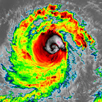
| | | | | |  | | Worldview Images of the Week | | | | | |
| | | | | | NASA's Earth Science Data Systems (ESDS) Program oversees the life cycle of NASA’s Earth science data and seeks to maximize the scientific return from missions and experiments. |
|