| | | | | | | |  | | | | OPEN ACCESS FOR OPEN SCIENCE | MARCH 2023 |
| | | | | | | |
| | | | | | |  | | | | | | | | | | | | | | | | NASA’s end-to-end Earth science data system enables America’s agricultural producers to make informed decisions about global market conditions, water management, in-season crop conditions, severe weather, and sustainability.
NASA has a vast array of agriculture-related resources. Our updated Data Pathfinder guides you through the process of selecting and using data, provides links to specific data sources, and points you to tools for working with these data. | | | | | |
|  | | The Agriculture and Water Management Resource Spotlight is a quick reference to articles, Data User Profiles, tutorials, webinars, and other relevant NASA Earth Science Data Systems (ESDS) Program resources. | | | | | |
| | | | |  | | Articles | | | | | |
| | | | | | |  | | From Earth Science Data to
Environmental Justice
NASA Earth science data help further environmental justice (EJ). Dr. Yaítza Luna-Cruz, one of the leaders of the agency’s EJ initiatives, explains why environmental justice matters and how NASA data play a critical role in these efforts. | | | | | | | |  | | NASA Funds the Future
NASA is awarding $11.7 million to eight Historically Black Colleges and Universities (HBCUs) to enable data science research that will benefit agency missions. | | | | | | | |  | | Exploring Terrestrial Ecosystems
NASA Earth science data help Dr. Kyla Dahlin model terrestrial ecosystems and figure out their future states. | | | | | | | |  | | The Man Behind the Machine (Learning): Iksha Gurung
As leader of the NASA Interagency Implementation and Advanced Concepts Team (IMPACT) development and machine learning (ML) team, Iksha Gurung is a guiding force in NASA ML work and research. | | | | | | | |  | | Recovering Historic Climate Data
The recovery of data collected by NASA’s earliest Earth observation missions is helping the European Copernicus Climate Change Service (C3S) compile a multi-decadal satellite data record for climate research. | | | | | | | |  | | Of Mice and Machines
Machine learning algorithms were used to help identify important feature genes contributing to the physical characteristics (such as gender, age, etc.) of samples taken from mice flown in space. | | | | | | | |  | | The Ethics of Large Language Models
Large Language Models (LLMs) are machine learning models that process and generate human language based on large-scale text data (ChatGPT utilizes the GPT-3 LLM). LLMs can help further open science, but there are challenges that must be addressed. | | | | | | | |  | | Continuing the AIRS Data Record
Next-generation instruments aboard Joint Polar Satellite System spacecraft provide continuity to the Atmospheric Infrared Sounder (AIRS) data record that began in 2002. | | | | | | | |  | | How Can the SNWG Help You?
The Satellite Needs Working Group (SNWG) routinely surveys U.S. federal civilian agencies to determine their satellite Earth observation needs. NASA’s SNWG Management Office assesses these needs. Read more about the 2022 SNWG biennial assessment. | | | | | | | |  | | 2022 Space Apps Challenge Winners
Ten global teams took home top honors in the 2022 NASA International Space Apps Challenge. The goal of the Space Apps Challenge is for teams to create open-source solutions to address challenges on Earth and in space. | | | | | |
| | | | |  | | New Data | | | | | |
| | New Processing Options for SAR Data The Alaska Satellite Facility has new processing options available for On Demand Sentinel-1 Radiometric Terrain Correction (RTC), which corrects distortions inherent to Synthetic Aperture Radar (SAR) images. | | | | | | | | OMPS LP Ozone Data Product Released Suomi National Polar-orbiting Partnership (Suomi NPP) Ozone Mapping and Profiler Suite (OMPS) Limb Profiler (LP) data have been reprocessed with the updated Version 2.6 ozone retrieval algorithm. | | | | | | | | New Soil Moisture Data Product A new Spire commercial smallsat soil moisture data product is available through the Smallsat Data Explorer (SDX). This release includes an additional nine months of historical data previously not available. | | | | | | | | Updated Precipitation Data Products Updated NASA Making Earth System Data Records for Use in Research Environments (MEaSUREs) Global Precipitation Climatology Project (GPCP) Daily and Monthly Products are available. | | | | | | | | New Aerosol Dataset A new dataset created from data collected by the NASA Atmospheric Tomography Mission (ATom) provides information about lower stratospheric aerosol characteristics and formation. | | | | | |
| | | | | |  | | Webinars | | | | | |
|
| | | | |  | | Open Workshops | | | | | |
| | | | |  | | Funding Opportunities & Solicitations | | | | | |
| | | | | |  | | ROSES (and Data Management Plans) for Valentine’s Day
New requirements in the annual NASA Research Opportunities in Space and Earth Sciences (ROSES) solicitation ensure that open science and data management are top priorities. | | | | | | | |  | | The Future of Terra, Aqua, and Aura Data
As NASA’s Terra, Aqua, and Aura satellites near the end of their life, NASA is seeking input for a workshop to discuss the future and continuity of data from these missions. Responses to the Request for Information (RFI) are due April 4. | | | | | |
| | | | | |  | | Connect with NASA Earth Science | | | | | |
| | | | | |  | | Worldview Images of the Week | | | | | |
| | 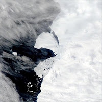 | | Massive Iceberg in the Antarctic A 1,550 km2 iceberg (about 600 square miles or roughly twice the size of New York City) calved from the Brunt Ice Shelf in the Weddell Sea, Antarctica. | | | | | | | |  | | Fires Roar Through Chile A summer heat wave and strong winds helped fan widespread fires that raged through south-central Chile in February. By February 20, the fires had left 25 dead and burned almost 441,000 hectares. | | | | | | | |  | | Tropical Cyclone Freddy over Madagascar The intense storm caused widespread wind damage and flooding in Madagascar, where authorities reported 7 fatalities, more than 22,000 displaced, around 80,000 affected, and 12,000 houses damaged. | | | | | | | | View more Images of the Week
NASA's Earth Science Data Systems (ESDS) Program oversees the life cycle of NASA’s Earth science data and seeks to maximize the scientific return from missions and experiments.
Interested in working with NASA’s
ESDS Program? Explore Opportunities
Contact Us
| |
|
|
|
|


