| | | | | | | |  | | | | OPEN ACCESS FOR OPEN SCIENCE | DECEMBER 2022 |
| | | | | | | |
| | | | | | | 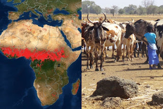 | | | | | | | | Left image: Each red dot across the Sahel region of Africa on this FIRMS Fire Map from Jan 31, 2022, is a detected fire. Right image: Burning farmland in the Sahel is a practice of the many farmers who inhabit the region. | | | | | | | | | | | | | | | | Looking at the Fire Information for Resource Management System (FIRMS) Fire Map, it sometimes appears as if much of Africa is on fire. But what is detected from space is only a small sample of how fire shapes the land and culture of this continent. | | | | | |
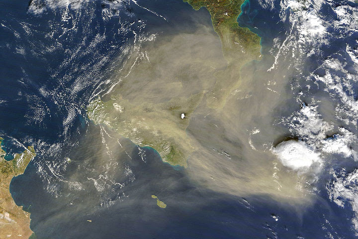
|  | | Suspended particles from fires can reduce visibility and contribute to health issues. Overlaying the Aerosol Index Layer (right image) on a true-color image of fires in Pakistan and India (left image) makes it easier to see areas of poor air quality. | | | | | |
| | | | | | | The Wildfires Data Pathfinder is your
gateway to wildfire-related data, tools,
and resources. | Get Started | | | | | | |
| | | | |  | | American Geophysical Union (AGU) | | | | | |
| |  | | | | | | | | NASA in the Windy City
| | | | | | | | The American Geophysical Union (AGU) Fall Meeting in Chicago, December 12-16, is a great opportunity to learn about the latest NASA Earth science data, tools, and services. Whether you participate in-person or online, we hope to see you there! | | | | | |
| | Members from ESDS Interagency Implementation and Advanced Concepts Team (IMPACT) are giving oral, poster, and online presentations during the AGU Fall Meeting: | |
| | | | |  | | Articles | | | | | |
| | | | | | |  | | Continuing OMI's Long-Term Data Record
The Aura satellite’s Ozone Monitoring Instrument (OMI) has provided data on atmospheric pollutants, trace gases, and aerosols since 2004. Now, as Aura nears retirement, plans are in place to continue OMI’s invaluable data record for years to come. | | | | | | | |  | | NASA SIPS Help Ease the Transition to JPSS
NASA’s Suomi NPP Science Investigator-led Processing Systems (SIPS) have played a key role in extending the long-term climate monitoring that began with Earth Observing System missions and will continue under the Joint Polar Satellite System (JPSS). | | | | | | | |  | | When Lightning Strikes
Dr. Timothy Lang likes to say that he “studies everything between the surface of the ocean and the base of the ionosphere.” Read more about his lightning studies using NASA Earth science data in a new Data User Profile. | | | | | | | |  | | Two Roles, One Mission: A Data Chat with Karen Michael
System Manager Karen Michael ensures that NASA Earth science data users are getting the data they need. In a recent Data Chat, she talks about her career path, NASA data users, and the future of near real-time data. | | | | | |
| | | | |  | | News | | | | | |
| | | | | | 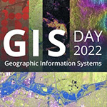 | | Celebrate GIS Day 2022!
GIS Day is an annual event celebrating the technology of Geographic Information Systems (GIS). Learn more about how NASA uses GIS to analyze relationships and impacts. | | | | | |
| | | | | |  | | Blogs | |
| | | | | |  | | Webinars | | | | | |
| | | | | | |  | | Applications, Datasets, & Open Science | | | | | |
| | | | | |  | | The POWER of DAVe
What can DAVe do for you? The enhanced Data Access Viewer (DAVe) from NASA’s Prediction Of Worldwide Energy Resources (POWER) project is your entry to data related to renewable energy, sustainable infrastructure, and agricultural planning. | | | | | | | | 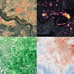 | | Easier Access to Environmental Justice Data
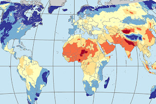
Combining NASA Earth science data with socioeconomic data about race, ethnicity, poverty, and health makes it easier to pinpoint vulnerable communities. The new Environmental Justice Data Catalog is a great starting point for finding these data. | | | | | | | | 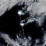 | | See What’s New in Worldview
From storm and natural event tracks to a wind speed overlay, the NASA Worldview team has added new features that increase the usability and utility of this popular application. See what you can now do with Worldview! | | | | | | | |  | | The Air Up There
“Exploring NASA’s Air Quality Resources for GIS” is a new StoryMap by the ArcGIS Distributed Active Archive Center Collaboration (ADC) featuring NASA GIS products focusing on air quality measurements and effects. | | | | | | | |  | | Seeking TOPST Reviewers
NASA’s Transform to Open Science (TOPS) team is seeking volunteer reviewers for the Transform to Open Science Training initiative. Serving as a reviewer is a great way to help further NASA’s open science efforts. | | | | | | | Explore more new datasets | | | | | |
| | | | | |  | | Worldview Images of the Week | | | | | |
| | 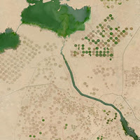 | | Farming the Desert Pivot irrigation circles and dark irrigation canals stand out in this true-color image of the New Valley Project in Egypt. Water is diverted from Lake Nasser, southeast of this image, to irrigate lands near the Toshka Lakes, shown at the top. | | | | | | | |  | | Where the River Meets the Sea The dark water of the Amazon River and the Tocantins River contrasts with the verdant Brazilian rainforest in this image of the Amazon Delta. | | | | | | | | View more Images of the Week | | | | | |
| | | | | | NASA's Earth Science Data Systems (ESDS) Program oversees the life cycle of NASA’s Earth science data and seeks to maximize the scientific return from missions and experiments. |
|
|
|