| |  | | | OPEN ACCESS FOR OPEN SCIENCE | NOVEMBER 2022 |
| |
|
| | | | | |  | | | | | | | | Citizen scientists record lake height data at Atranga Dighi. More than 400 gauge readings are available at this location. Credit: Lake Observations by Citizen Scientists and Satellites (LOCSS). | | | | | | | | A NASA Citizen Science for Earth Systems Program (CSESP)-funded effort uses a combination of satellite data and citizen scientists to give the government of Bangladesh its first accurate record of the country’s surface water storage. | | | | | |
|  | | Water quality can be impacted by many factors that can be tracked remotely. The Water Quality Data Pathfinder is your guide to data, tools, and resources that can help you get a better idea of the health of lakes, rivers, and the global ocean. | | | | | |
| | Are you new to using NASA Earth science data or exploring new areas of research? Need new tools to analyze and work with data? Start with NASA Earthdata. | Get Started | |
| | | | |  | | Articles | | | | | |
|
| | | | | |  | | Simplifying SAR
When the Arizona Department of Water Resources lost 70 terabytes of synthetic aperture radar (SAR) data from a server malfunction they needed a solution—fast. Read how the Alaska Satellite Facility’s OpenSARLab came to the rescue. | | | | | | | |  | | Landsat Active Fire Data Added to FIRMS
NASA’s Fire Information for Resource Management System (FIRMS) added a new near real-time Landsat Fire and Thermal Anomalies product for the continental U.S., southern Canada, and northern Mexico that offers high-resolution fire detection data. | | | | | | | |  | | A Small Sensor with a Big Job
How can a satellite with dimensions measured in centimeters provide ground-breaking data about tropical cyclones? Read how Dr. William J. Blackwell uses constellations of CubeSats to study storm intensity. | | | | | |
| | | | |  | | News | | | | | |
| | | | | |  | | Environmental Justice Gets UNBOUND
The Understanding Needs to Broaden Outside Use of NASA Data (UNBOUND) project is making NASA data, tools, and resources more usable and accessible to a broader community. Learn more in the report from the UNBOUND-Environmental Justice workshop. | | | | | | | |  | | GHGSat Data Selected for Evaluation
As part of the Commercial Smallsat Data Acquisition (CSDA) program’s On-ramp #3, NASA selected GHGSat to provide greenhouse gas data for evaluation. GHGSat satellites are capable of measuring methane emissions from individual oil and gas wells. | | | | | | | |  | | Taking Flight at the 2022 Space Apps Challenge
A challenge developed by NASA’s Airborne Data Management Group (ADMG) called “Take Flight: Making the Most of NASA’s Airborne Data” was part of this year’s International Space Apps Challenge; 140 teams contributed solutions to this challenge. | | | | | |
| | | | | |  | | Blogs | |
| | | | | |  | | Saving Airborne Data
NASA’s P-3 aircraft has been instrumental in the agency’s Earth science research efforts since the early 1990s. Work by two ADMG members is giving new life to airborne data collected in the 1990s and early-2000s. | | | | | | | | 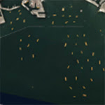 | | IMPACTful Researchers
The ESDS Interagency Implementation and Advanced Concepts Team (IMPACT) is finding new ways to apply machine learning and artificial intelligence to NASA data. Read about the work of two members of IMPACT’s informatics group. | | | | | |
| | | | | |  | | Webinars | | | | | |
|
| | | | | |  | | Applications & Datasets | | | | | |
| | | | | |  | | Open Workshops | | | | | |
| | | | | |  | | S-MODE Workshop
The Submesoscale Ocean Dynamics and Vertical Transport Experiment (S-MODE) is a NASA mission that will provide an unprecedented view of ocean transport. Register by November 18 for this virtual Open Data Workshop that will be held December 1, 2022. | | | | | |
| | | | | |  | | Worldview Images of the Week | | | | | |
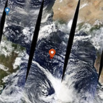
| | 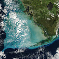 | | In the Wake of Ian As Hurricane Ian moved across Florida in late-September, it churned up vast amounts of sediment. This is clearly seen in this true-color image from September 30 showing the southern tip of Florida. | | | | | | | |  | | Washington State Wildfires Each orange dot on this true-color image from October 16 is a wildfire burning in Washington state. Smoke blowing to the northwest gives an idea of the prevailing wind. | | | | | | | |  | | Life in Lake Michigan The green swirls in this October 22 image of the south shore of Lake Michigan are living organisms called phytoplankton. Phytoplankton use the Sun's energy to turn carbon dioxide and water into food and energy via photosynthesis. | | | | | | | | View more Images of the Week | |
| | | | | | NASA's Earth Science Data Systems (ESDS) Program oversees the life cycle of NASA’s Earth science data and seeks to maximize the scientific return from missions and experiments. | | | | |
|