| | | | | |  | | Planning Ahead for More Data Tomorrow
Data collection from the Clouds and the Earth’s Radiant Energy System (CERES) instruments aboard NASA’s Terra and Aqua satellites will soon end. But the CERES data record will continue. | | | | | | | |  | | Visualizing with VEDA
The new Visualization, Exploration, and Data Analysis (VEDA) Dashboard enables users to interactively explore Earth science data and information in multiple theme areas. | | | | | | | | 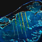 | | UNBOUND Lowers Barriers
NASA’s Understanding Needs to Broaden Outside Use of NASA Data (UNBOUND) project is a series of domain-specific workshops designed to match analysis and visualization practitioners in target communities with NASA data scientists and others knowledgeable in the field. | | | | | | | | 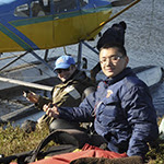 | | Watering Down NASA Data
Freshwater not only makes your garden grow, it also makes society work. See how Dr. Jida Wang uses NASA data to study and monitor this vital resource. | | | | | |
| | | | | |  | | Blogs | |
| | | | | |  | | A Student Earth Scientist Takes Flight
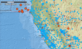
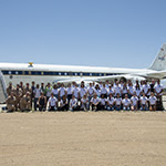
From flights aboard NASA research aircraft to data collection field trips along the California coast, NASA’s Student Airborne Research Program (SARP) helps students interested in airborne science earn their wings. | | | | | | | |  | | Terra Satellite Milestone
NASA’s Terra satellite exits the Morning Constellation of the Earth Observing System (EOS) satellite program this month. During this constellation exit maneuver, science and near real-time data will not be acquired from October 10 to 19, 2022. | | | | | | | | 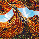 | | AI as Art
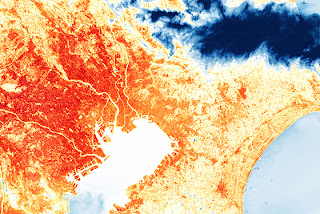
What is the skill of artificial intelligence (AI) in creating art? NASA IMPACT Manger Dr. Rahul Ramachandran attempted to find out by creating AI art and getting a critique from his father, an accomplished artist. | | | | | |
| | | | | |  | | Funding Opportunity | |
| | | | | |  | | Transform to Open Science Training (TOPST)
Have an idea for supporting NASA open science efforts? The Transform to Open Science (TOPS) team wants to hear from you! Submit your Notice of Intent to the TOPS Training (TOPST) solicitation by November 10. | | | | | |
| | | | | |  | | Webinars | | | | | |
|
| | | | | |  | | Applications & Datasets | | | | | |
| | | | | | Historic Rainfall in St. Louis When it rains, it pours. And when it rained in St. Louis, MO, from July 25-26, 2022, it led to historic flooding. This Data in Action story explores the causes of this flash flooding event. | | | | | | | | Assessing the Quality of the Air We Breathe Fine particulate matter, ozone, and nitrogen dioxide pose huge risks to public health. A new data collection at NASA’s Socioeconomic Data and Applications Center (SEDAC) makes it easier to track these pollutants. | | | | New in Giovanni Orbiting Carbon Observatory-2 (OCO-2) Level 3 global mapped carbon dioxide atmospheric concentration data. The OCO-2 mission provides the highest quality space-based XCO2 retrievals to date. Check them out! | | | | | | | | Tracking Trends in Urban Growth from Space A new SEDAC dataset traces patterns and trends in urban settlements from 1993 to 2020 based on satellite microwave backscatter. | | | | | | | | Explore more new datasets | | | | | |
| | | | | |  | | Read All About It! | | | | | |
| | NASA data helped uncover the mystery behind a unique phytoplankton bloom in Micronesia. Read the details in a recently published peer-reviewed article: doi.org/10.3390/earth3030056 | | | | | |
| | | | | |  | | Worldview Images of the Week | | | | | |
| | 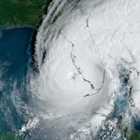 | | Hurricane Ian Approaches Florida Hurricane Ian, with winds greater than 150 mph, slammed into the west coast of Florida in late-September. The storm caused catastrophic flooding and wind damage. | | | | | | | | 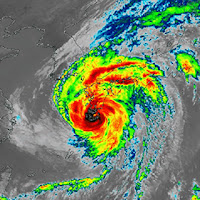 | | Super Typhoon Nanmadol A super typhoon is the equivalent of a Category 4 or Category 5 hurricane. Super Typhoon Nanmadol hit the Japanese islands in mid-September, causing the evacuation of 9 million residents. | | | | | | | | 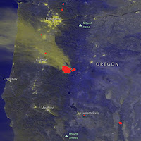 | | Cedar Creek Fire, OR After more than two months, the Cedar Creek Fire in western Oregon is less than 50% contained. The fire began August 1 when lightning ignited 20 to 30 new fires in the Willamette National Forest that continue to burn at low intensity. | | | | | | | | View more Images of the Week | |
| | | | | | NASA's Earth Science Data Systems (ESDS) Program oversees the life cycle of NASA’s Earth science data and seeks to maximize the scientific return from missions and experiments. | | | | |
|