Σελίδες

Τρίτη 9 Αυγούστου 2022

NASA's LATEST


AUGUST 8, 2022

Natural Events

   
Image iconLATEST IMAGES FROM THE PAST 7 DAYS
view archive of natural events
   
   
Extreme Rainfall Leads to Midwest FloodingExtreme Rainfall Leads to Midwest Flooding

Such extreme precipitation events and weather are becoming more likely with climate change. (Aug 2, 2022)

   
NASA | 8800 Greenbelt Rd.Greenbelt, MD 20771
OPEN ACCESS FOR OPEN SCIENCE | AUGUST 2022


 Heat
In the United States, pervasive and persistent heat domes put more than 150 million people under heat warnings and advisories in the month of July. Image courtesy NASA's Earth Observatory.


Extreme Heat Data Pathfinder

NASA data may not help you beat the heat, but they are a vital tool in assessing where extreme temperatures may occur, exploring the role of urban heat islands, and tracking land surface temperature over time.


Are you new to using NASA Earth science data or exploring new areas of research? Need new tools to analyze and work with data? Start with NASA Earthdata.

Get Started 
 
 
Article iconArticles 
 
 Fire Information for Resource Management Service (FIRMS)Ultra Real-Time Wildfire Detection Data

A new service provides satellite wildfire detection data from MODIS and VIIRS for the continental U.S. in less than 60 seconds through NASA's Fire Information for Resource Management Service (FIRMS).

New FIRMS tips:


 Ryan BollerData Chat: Ryan Boller

Ryan Boller, ESDIS Data Visualization Lead, plays a key role in the development of NASA’s Global Imagery Browse Services and Worldview.


 Dr. Zhong LuData User Profile: Dr. Zhong Lu

Data from NASA’s Alaska Satellite Facility (ASF) DAAC help scientists like Dr. Zhong Lu develop satellite radar remote-sensing techniques for studying geohazards.


 Common Metadata Repository (CMR)Common Metadata Repository Surpasses 1 Billion Data Records

One billion of anything is an exceptional milestone. One billion data records in NASA’s Common Metadata Repository (CMR) are making NASA Earth science data easier to find.


 Dr. Manil Maskey and the COVID-19 DashboardInternational Space Agency Teamwork Puts the Whole World in Our Hands

NASA data scientist Dr. Manil Maskey led NASA's collaboration with ESA (European Space Agency), and the Japan Aerospace Exploration Agency (JAXA) to develop a user-friendly interactive computer interface for exploring the planet and tracking its changes over time. COVID-19 triggered the tool's creation.

Visit the NASA COVID-19 dashboard


Webinars iconWebinars
 
 webinar 
 
Moving Code to the Data: Analyzing Sea Level Rise Using Earth Data in the Cloud

What can you do with data in the Earthdata Cloud? Experts at NASA’s Physical Oceanography Distributed Active Archive Center (PO.DAAC) show how to discover and access cloud-based physical oceanography data and utilize cloud computing to analyze global sea level rise.


Solicitations & Opportunities iconOpen Events
 
TOPS Community Forum
August 11, 2022

The next Transform to Open Science (TOPS) Community Forum takes place Thursday, August 11, 1 PM EDT and will include interactive discussions of each of the TOPS OpenCore curricula modules. Register and learn more.

Open Source Science Data Repositories Workshop
September 27-30, 2022

Of specific interest to researchers, big data teams, and archivists from NASA Science Mission Directorate (SMD) Data Repositories, the purpose of this open workshop is to engage with the repositories on the next steps in sharing scientific information and open science. Register by August 10th.


New Data iconDataset Announcements
 
Daily and Annual NO2 Concentrations for the Contiguous United States, 1-km Grids, v1 (2000–2016)

Useful for estimating short- and long-term effects of nitrogen dioxide on human health and other related research.

 
Groundswell Spatial Population and Migration Projections at One-Eighth Degree According to SSPs and RCPs, v1 (2010–2050)

Understand how slow-onset climate change impacts on water availability and crop productivity, coupled with sea-level rise and storm surge, may affect future population distribution and climate-related internal migration in low- to middle-income countries.

Explore more new datasets


Technology Spotlight iconWorldview Images of the Week
 
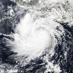
 ###Hurricane Bonnie Off the Coast of Mexico

Hurricane Bonnie was a rare tropical storm that jumped from the Atlantic to the Pacific Ocean. This NOAA-20/VIIRS image shows Bonnie on July 4, 2022, when it was a Category 3 storm with maximum sustained winds of 115 mph and wind gusts up to 138 mph.


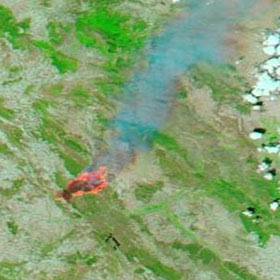
 ###Fire in Aragon, Spain

A spark from an excavator near Aragon, Spain, led to a wildfire in the Ateca forest that burned almost 35,000 acres. This Aqua/MODIS false color image from July 19 shows the active fires and burn scar.


View more Images of the Week